|
|
|
|
|
Thursday 12th Anne’s official birthday. Again just had supermarket fruit bowl in the room. Skyped Tracey and Niamh to wish her happy birthday.
Continued north and stopped at Yellowhead Lake and then a little later at the much larger Moose Lake. We’d looked up Mt Robson and found that it’s actually the highest mountain in the Rockies so we drove onto there which anyway was the first place where you could get coffee.
While
we sat with our coffee we saw a bunch of people gathered round a
tree nearby taking phot After setting off from Mt Robson we turned south on the Yellowhead South Highway (5) alongside the North Thompson River. It gradually became flatter with wider valleys and we were surrounded by tree covered hills rather than snow-capped mountains. There was virtually nothing on the road until we came to Blue River where we went into a small petrol station that had three small tables. We grabbed a quick lunch and carried on. We stopped, with an hour to go, at Barriere and had a cup of tea. We chatted to a couple of Canadian ladies and were astonished when their ‘breakfasts’ came out. I think even they were surprised as one lady kept offering some of the huge pile of pancakes that accompanied her huge meal. At Barriere it rained quite heavily while we were in the cafe. As we drove on after that we eventually got to some very heavy rain but then this seemed to continue up a different valley and our road became dry again. As we reached Kamloops we realised that it’s far, far larger than we’d imagined. The BW is large and quite imposing and we have an excellent room. We didn’t have much to do as we’re moving on tomorrow. However we did discover that the internet connection is very high speed. As we had plenty of time we downloaded the photos and they uploaded to the Dropbox in no time at all. We also sent a few emails.
We went out about 6.30 and checked with the front desk who said they were quite happy to supply plates and cutlery from the breakfast room. We put Safeway in the satnav and it showed it only a few mins away. Anne said that this would be the one that we’d passed on our way in (Les had been driving). We set off and all of a sudden noticed the Safeway had become much further away. We then had a series of mishaps. Les took a wrong turn where the road splits and missed the bridge over the river. We thought this would be no trouble and the satnav was obviously trying to take us back by doing a loop round some local roads. Unfortunately our way was blocked by some temporary roadworks. After a couple of goes we finally got back on the route and eventually found the Safeway. This is strange - it’s not the Safeway we saw on our drive in as it’s tucked away at the back of a retail park and it’s obviously much further away. In fact as we type this we’ve realised we can see a Safeway on a large building from our window. Anyway we found that they had some fish for Anne and Les bought some chicken and we got the usual Caesar salad and a French stick, all for C$20 and we came back to our room and had it with a couple of the remaining beers. Typed this up before starting to plan for tomorrow - another long drive. |
|
Friday 13th
Up
early and down to breakfast. We found a table but while we were
getting our stuff there was a couple who couldn’t find anywhere to
sit so we asked them to join us. He was Canadian and she was
American and they were in town for their son’s graduation. By
amazing chance it turned out that his great-grandfather came from
Eventually left about 9.30am and started by going east on the 1. Stopped at overlook on Kamloops Lake. Next stop was Cache Creek for a coffee at somewhere that turned out to be a Dairy Queen. Carried on and then turned off onto the 99 and started heading south down through the mountains. The road not so good but virtually no traffic. Went through Marble Canyon - which seems to be limestone which they use to make lime. As we drove through this area there were quite a few isolated homes (farms?). A repeated feature was that all of them seemed to have a collection of rusting pick-up trucks, often half a dozen or more. Not quite sure why they’re simply not traded in when the next one is bought. Much of what we were going through was First Nation Reserves. Continued down with odd stops at lakes and waterfalls until we got to Lilloouet where we went off route into the town for lunch.
We carried on down the 99. Stopped for a splendid waterfall that goes under the road and into the river which at this point is the Cayonah Creek. Continued on and stopped at the boat ramp into Duffey Lake where we were fascinated by a large build up of logs. Not quite clear why they’re all there because the lake continued beyond the logs. Stopped in Pemberton for a drink mid-afternoon. On down a winding road with various bits of roadworks as far as Whistler. We didn’t stop in Whistler because it was raining so much. Out of Whistler and due south quite a long way, eventually ending up in Squamish. The BW is at the end of an industrial estate. We didn’t fancy the adjacent restaurant but we noticed there was a Wallmart nearby. We went there with high hopes only to find that here (in Canada generally?) Wallmart didn’t do nearly the range of fresh food that we’ve found in the US. Instead we bought a pack of plastic plates and some very cheap knives and forks in the hope of finding somewhere else. Les also bought some superglue which he used later that evening to do a successful temporary repair on his lens hood.
Les nipped into the liquor store next to the BW and bought a box of beers while Anne sorted out the food. After we’d eaten and cleared away we sorted out photos and sent some emails. We then got into bed and opened Les’s cards. Some extremely good ones - especially Martin & Jenny’s one using the Streetview picture and Tina’s handmade one. Bill & Bren’s Simon Drew card of car makes kept us guessing for a while. |
|
Saturday 14th
It should have been a 40 minute drive to the ferry, but we started by stopping immediately for photos overlooking Howe Sound. Strangely in the car park of this small viewpoint there was a statue to Giuseppe Garibaldi. In fact much of the area to the east of the 99 between Pemberton and Squamish is the Garibaldi Provincial Park, centred around Mount Garibaldi. We subsequently discovered that he has absolutely no connection with the area, it’s simply the fact that one of the early British military pioneers in the area was an admirer of him. Pushed on ignoring several other viewpoints along the Sound, but stopped at one near Brittannia Beach where we learnt a little of the copper mining background of the area. While there we noticed that despite the fact that the road is extremely steep and very long between towns, there were an amazing number of serious cyclists. Cycling is obviously a big thing around here (and indeed around the whole of the area we’ve been through) judging by the number we’ve seen and the various signs exhorting motorists to share the road. We’d seen Lions Bay on the map and decided that, simply because of its name, this village would make a good coffee stop. Getting there proved a bit of a nightmare. The first exit took us down incredibly steeply and then ended in a cul-de-sac. We managed to get back on to the 99 and take the next exit. This led uphill (or rather up mountainside) via some narrow windy and very steep roads until eventually we got to the cafe (which in fact was very well signed). Inevitably one of the few other people in the cafe was a cyclist, although goodness knows how he got there.
We set off and arrived about 20 mins late. An absolutely calm journey much to our relief. Despite the ‘heavy traffic’ the boat didn’t seem particularly full given that there were large numbers of empty seats in all areas, although Anne noticed that a lot of people remained in their cars. |
|
|

 Set
off around 9.45am westward on Highway 16. Still quite mountainous
for a while but got slightly less impressive the further we got from
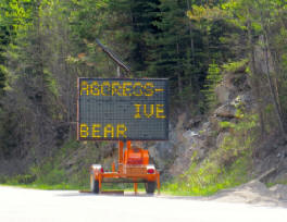
Jasper. We stopped to photograph a temporary matrix sign warning of
an ‘aggressive bear’ and telling drivers to stay in vehicles.
Carried on and stopped at a small lake by the entrance to Mt Robson
Park. This also marked the province boundary as we went back into
British Columbia. Fortunately we noticed the sign that mentioned the
time change so we put our watches back an hour and this time
remembered to change the cameras as well. [This created havoc trying
to sort out the photos when we got home.]
Set
off around 9.45am westward on Highway 16. Still quite mountainous
for a while but got slightly less impressive the further we got from
Jasper. We stopped to photograph a temporary matrix sign warning of
an ‘aggressive bear’ and telling drivers to stay in vehicles.
Carried on and stopped at a small lake by the entrance to Mt Robson
Park. This also marked the province boundary as we went back into
British Columbia. Fortunately we noticed the sign that mentioned the
time change so we put our watches back an hour and this time
remembered to change the cameras as well. [This created havoc trying
to sort out the photos when we got home.]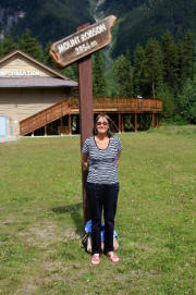 os.
We discovered that there’s a bird feeder filled with sugar water
that attracts hummingbirds. We managed to get a few reasonable
pictures before taking the obligatory shots of Mt Robson itself.
os.
We discovered that there’s a bird feeder filled with sugar water
that attracts hummingbirds. We managed to get a few reasonable
pictures before taking the obligatory shots of Mt Robson itself. We
mulled over what to do about eating. Eating out would inevitably
mean driving as there is nothing within walking distance apart from
a few hotels with restaurants. There is a Chinese restaurant
immediately opposite but our experience of American Chinese isn’t
good. Looking on Trip Advisor we found one family restaurant that
seemed to be ok with fish but we weren’t really that bothered. The
satnav said that there was a Safeway quite nearby (we’d seen one on
our drive in).
We
mulled over what to do about eating. Eating out would inevitably
mean driving as there is nothing within walking distance apart from
a few hotels with restaurants. There is a Chinese restaurant
immediately opposite but our experience of American Chinese isn’t
good. Looking on Trip Advisor we found one family restaurant that
seemed to be ok with fish but we weren’t really that bothered. The
satnav said that there was a Safeway quite nearby (we’d seen one on
our drive in).  Wimborne
and he’d visited in the past.
Wimborne
and he’d visited in the past. 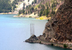 Went
back onto the road and almost immediately stopped at Seton Lake
Hydro lookout. To us this seemed equally as good as Maligne Lake,
although there are no activities on it. Possibly because it feeds
into the Hydro scheme. The rail route alongside must be really
spectacular.
Went
back onto the road and almost immediately stopped at Seton Lake
Hydro lookout. To us this seemed equally as good as Maligne Lake,
although there are no activities on it. Possibly because it feeds
into the Hydro scheme. The rail route alongside must be really
spectacular. 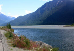 We
searched the satnav for grocery stores and found there was one 2km
away. It turned out to be a local store in the centre of the usual
retail mall - Nesters. Had a better range. Bought a Greek salad, a
veggie roll for Anne, some chicken for Les, bread and fresh fruit
and pastry breakfast. We’d successfully transported the butter from
yesterday by putting it in a sealed sandwich bag with a load of ice
from the hotel. Driving back to the hotel we spotted a warning sign
saying that the 99 would be closed Saturday morning from 10.25 to
11.05am. Quite important to us and lucky that we spotted it as this
is the only road to the ferry.
We
searched the satnav for grocery stores and found there was one 2km
away. It turned out to be a local store in the centre of the usual
retail mall - Nesters. Had a better range. Bought a Greek salad, a
veggie roll for Anne, some chicken for Les, bread and fresh fruit
and pastry breakfast. We’d successfully transported the butter from
yesterday by putting it in a sealed sandwich bag with a load of ice
from the hotel. Driving back to the hotel we spotted a warning sign
saying that the 99 would be closed Saturday morning from 10.25 to
11.05am. Quite important to us and lucky that we spotted it as this
is the only road to the ferry. 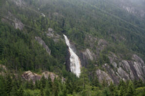 No
particular rush as we’d worked out that we needed to leave by 10.15.
Sorted ourselves out and typed up some of the diary before leaving.
Filled up at a gas station as we left Squamish - Ouch -
C$148.9/litre as opposed to the C$135.9 that we’ve been paying
elsewhere.
No
particular rush as we’d worked out that we needed to leave by 10.15.
Sorted ourselves out and typed up some of the diary before leaving.
Filled up at a gas station as we left Squamish - Ouch -
C$148.9/litre as opposed to the C$135.9 that we’ve been paying
elsewhere. 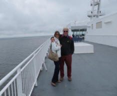 The
various stops had left us timed to arrive about 10 mins after the
earliest possible arrival time at the terminus. Getting to the
terminus from the 99 was interesting as the signs took off the 99,
around in a circle, back on it going northwards anf then off again.
The terminal organisation was very slick with lanes marked for the
various ferries. We had a slight panic when the man in the desk told
us our booking was for the return journey - he hadn’t realise that
the piece of paper was double-sided. We were given a coloured card
for our windscreen and directed to lane 2. We were really pleased
we’d booked as the queues for other lanes seemed very long. We
waited and it soon became obvious that we weren’t going to get away
on time, but an apology came over the tannoy to say they were
running late because of heavy traffic - tomorrow is Fathers’ Day so
possibly a lot of people had been travelling early in the day to or
from the Island.
The
various stops had left us timed to arrive about 10 mins after the
earliest possible arrival time at the terminus. Getting to the
terminus from the 99 was interesting as the signs took off the 99,
around in a circle, back on it going northwards anf then off again.
The terminal organisation was very slick with lanes marked for the
various ferries. We had a slight panic when the man in the desk told
us our booking was for the return journey - he hadn’t realise that
the piece of paper was double-sided. We were given a coloured card
for our windscreen and directed to lane 2. We were really pleased
we’d booked as the queues for other lanes seemed very long. We
waited and it soon became obvious that we weren’t going to get away
on time, but an apology came over the tannoy to say they were
running late because of heavy traffic - tomorrow is Fathers’ Day so
possibly a lot of people had been travelling early in the day to or
from the Island.